


Infrastructure Ministry approves new jurisdictional limits for Santos Port
Jul, 01, 2020 Posted by datamarnewsWeek 202027
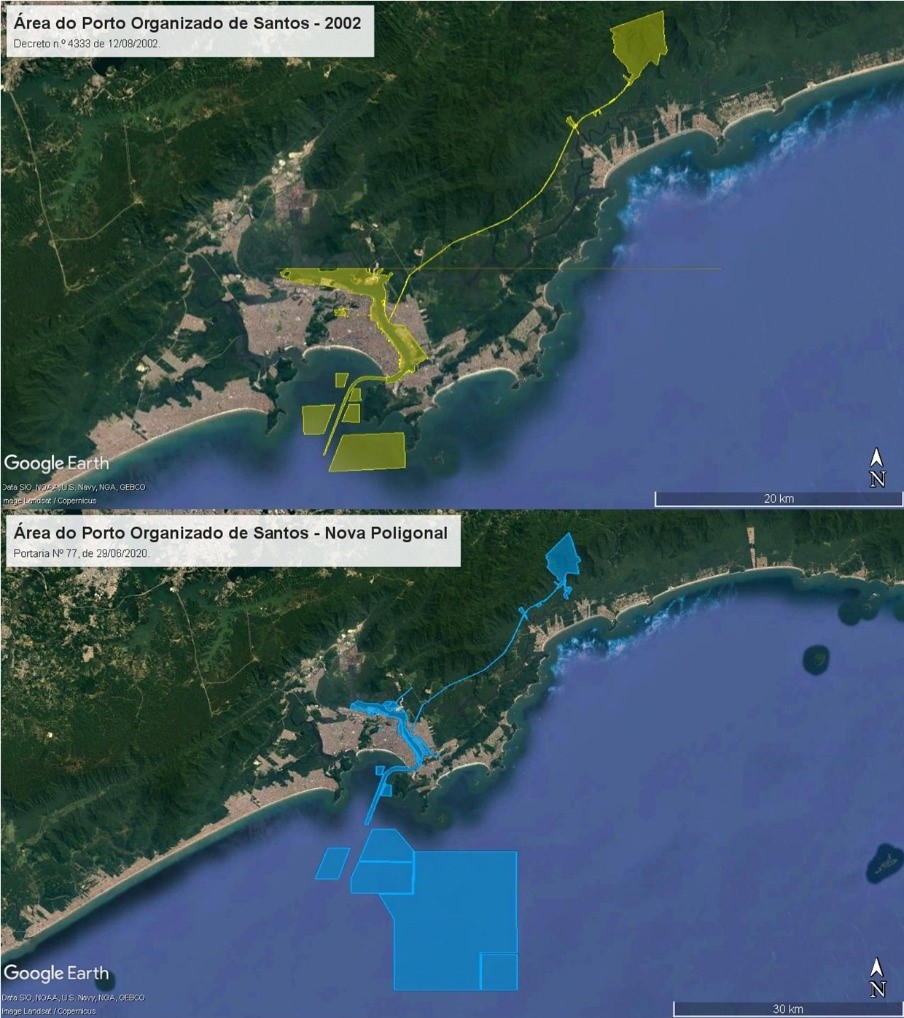
On Tuesday, June 30, the Infrastructure Ministry published Ordinance 77 that changes jurisdictional limits of the organized port of Santos, the most important in Brazil. The definition of the new polygonal (the name for the administrative perimeter that comprises accesses, facilities, leased terminals and expansion areas of the public port), updates the guidelines in force since 2002 and adapts the organized port to the Law of Ports (12,815, 2013), which differentiates leased and private terminals precisely because of what is inside or outside the polygonal. In addition, it paves the way for the approval of the new Development and Zoning Plan (PDZ), which provides for the lease of areas hitherto outside the jurisdiction of the Port Authority.
According to the agency, this brings legal certainty for agreements and leases and ensures predictability for long-term investments. In total, 32 of the 37 organized ports that have existed since the law was issued had their polygonal defined. “After 18 years, the new polygonal establishes a landmark for the modernization of the Port of Santos by allowing the realization of long-term planning according to the guidelines of the Ministry of Infrastructure to make the port more rational and efficient. It is another important step in the process that precedes the privatization of the country’s main port,” said Minister Tarcísio.
The new area of the organized port of Santos brings several new features compared to the old delimitation of the port jurisdiction. The main definition is the clear delimitation of the area of the organized port, through 79 precisely identified polygons, which will ensure that the port and the port community know exactly where the competence of the port authority begins and ends. In this way, legal security will be guaranteed to the port itself, to the municipalities, public administration bodies and entities and to society in general in the execution of its projects and activities, and in carrying out its duties.

Check out other important changes:
- Resolution of historical land conflicts between the port, the Secretariat of Patrimony of the Union and the municipality of Santos;
- Recognition of the Conceicãozinha community, in Guarujá, where hundreds of people reside, as an area of public interest for the purpose of land and urban regularization
- Respect for railroad tracks granted by the Union to private individuals;
- Incorporation of strategic union areas for the development of the port, such as land in Alemoa, on the perimeter and adjacent areas, on the right and left banks, and the access road to Barnabé Island;
- Withdrawal of port jurisdiction from areas occupied by small port facilities, in Guarujá, which will allow their regularization with SPU and ANTAQ;
- Removal of the land sections occupied by the DP World Terminal from the organized port area;
- Compatibility of private and public projects in the region, by adapting the limits of the organized port to billionaire enterprises designed for the region, such as the Brites and Santorini terminals;
- Compatibility of the delimitation of the aquatic spaces of the port jurisdiction to the delimitations of the structures for access, evolution, and anchoring of vessels, consolidated by the Brazilian Navy and INPH.
The following chart shows imports and exports via Port of Santos month by month from January 2017:
Graph source: DataLiner (To request a DataLiner demo click here)
Below is the participation of each terminal in the Port of Santos:

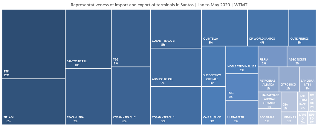
Graph source: DataLiner (To request a DataLiner demo click here)
-
Other Cargo
Feb, 22, 2022
0
Imports and costs threaten mask production in Brazil
-
Oil and Gas
May, 09, 2023
0
Petrobras will only build part of oil platforms in Brazil, top executive says
-
Ports and Terminals
Jan, 02, 2023
0
Port of Rio de Janeiro records 9.3 mln tonnes throughput Jan-Nov
-
Trade Regulations
Apr, 19, 2024
0
Brazil-USA Bilateral Trade Reaches US$ 18.8 bln in 1Q24